A drifter buoy is a free-floating, self-powered oceanographic instrument that goes where the current takes it instead of staying anchored. It rides the surface, trails a drogue about 15 metres down to follow the current below the wind, samples sea surface temperature, wind, waves or pressure, and ships each reading to shore by satellite.
The interesting part is that the buoy is not really a sensor platform. It is a moving sampling point. Every measurement it takes is stamped with a GPS position, and the trail of those positions is what oceanographers actually use.
Before the detail, five things explain most drifter systems:
- It goes with the current, not with the wind. A drogue below the surface is what makes that true.
- It measures where it is, not just what it is. Position plus time gives you drift velocity, which is the point of the whole instrument.
- Everything it senses is transmitted twice. High-frequency data stays onboard, low-frequency summaries go by satellite.
- It runs on very little power. Duty cycling, not battery size, is what decides how long a mission lasts.
- It eventually fails, usually predictably. Drogue loss is the normal ending, not the exception, and the data has to be flagged for it.
NOAA’s Global Drifter Program is the reference operation for all of this, and it publishes live positions publicly, so you can watch a real drifter’s path while you read.
Table of Contents
- What Is a Drifter Buoy?
- How Drifter Buoys Work from Surface to Satellite
- The Parts of a Drifter Buoy
- What Sensors Do Drifter Buoys Measure?
- How a Drifter Buoy Tracks Ocean Currents
- How Drifter Buoys Send and Store Data
- Why the Drogue Matters: Stability Below the Surface
- How Drifter Buoys Are Deployed and Recovered
- What Affects a Drifter Buoy’s Accuracy?
- Drifter Buoys vs. Other Ocean-Tracking Instruments
- Frequently Asked Questions
- Conclusion
What Is a Drifter Buoy?
A drifter buoy is a floating sensor package with no anchor, no mooring line and no ship attached to it. It is released from a research vessel, a cargo ship or an aircraft, and from that moment its only job is to float, measure, and report.
That makes it fundamentally different from the other floating instruments. A moored buoy is held to a point on the seabed by a mooring line and an anchor, so it samples one location repeatedly and tells you how conditions change over time at that spot. A drifter does the opposite: it samples a moving path and tells you what conditions are like along a line of water.
Oceanographers call that a Lagrangian measurement, after the physicist who described particles moving with a flow. A moored buoy gives you an Eulerian picture, a fixed point watched through time. Neither is better. A fixed station tells you about a place, a drifter tells you about a parcel of water as it travels.
What drifter buoys are actually used for
The core job is mapping surface currents over huge areas, which satellites cannot do directly. Satellite altimeters infer surface current from the shape of the sea surface, and that inference is good but indirect. A drifter measures it by drifting with it.
Around that sit the applications most people have heard of:
- Weather forecasting. Drifter observations feed the Global Telecommunications System and land in numerical forecast models within hours.
- Hurricane forecasting. A drifter caught in a storm becomes a real-time probe of the storm itself, measuring wind and pressure where ships cannot safely go.
- Climate records. Long-running sea surface temperature series show marine heatwaves and trends that satellite estimates alone leave uncertain.
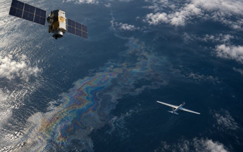
- Oil spill trajectory. Spill modellers need surface current vectors, and drifters are the most direct source near the spill.
- Marine debris tracking. The same Lagrangian logic applies to plastic, and a drifter or two is a cheap way to sample where floating debris accumulates.
- Coastal and surf work. Small drifters in fjords and nearshore water measure wave spectra and currents where model resolution is poor.
How Drifter Buoys Work from Surface to Satellite
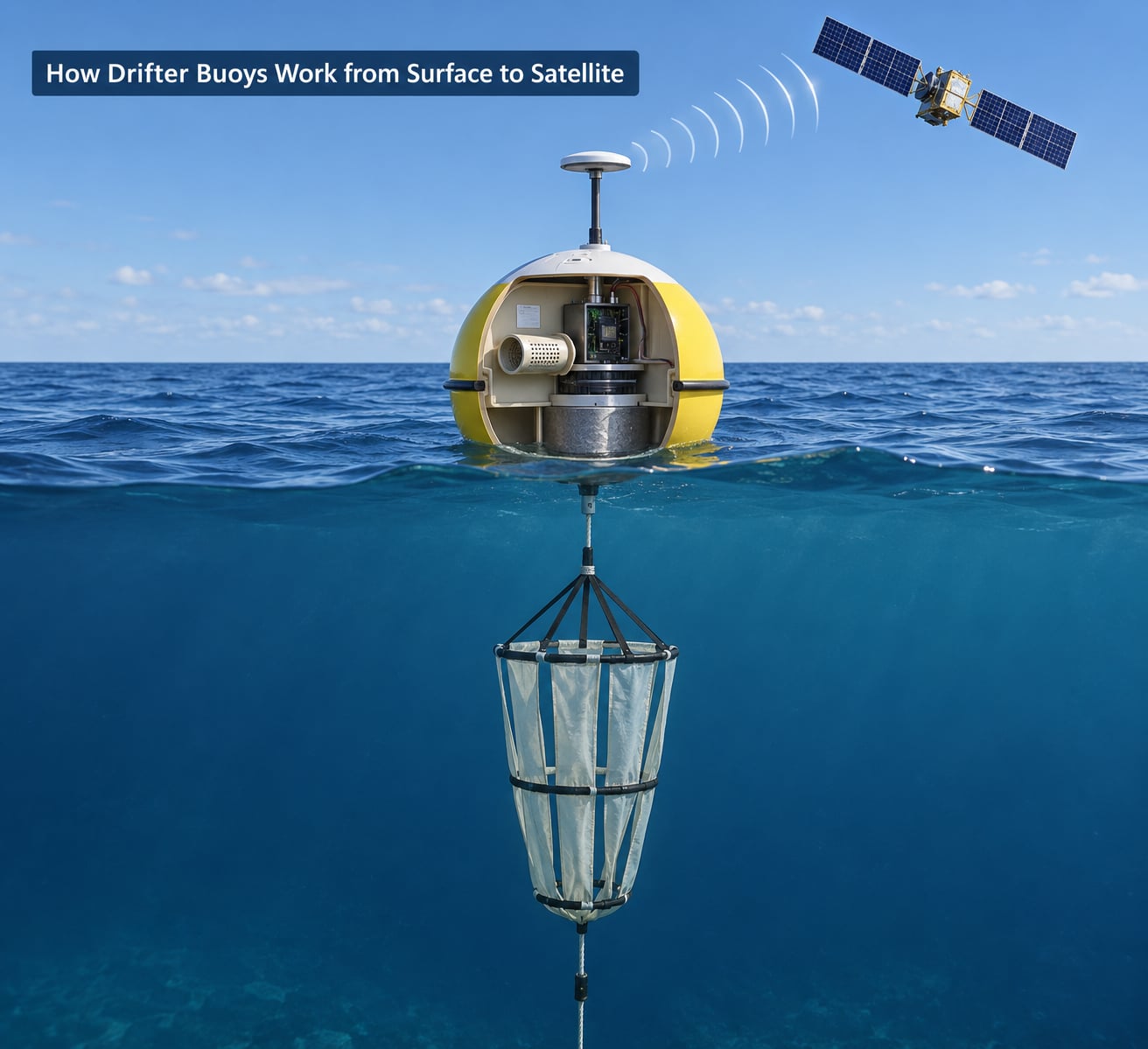
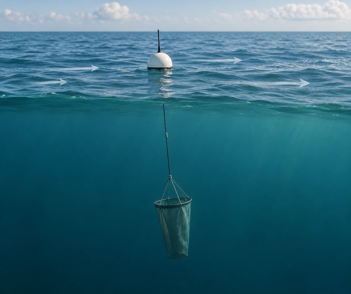
How drifter buoys work comes down to one physical trick: separating what pushes the buoy from what pulls it. Wind and waves push the float across the sea surface. The water below pushes the drogue. Make the drogue the dominant influence and you have a current meter.
The float sits high enough to keep the electronics dry and the antennas clear, with a sensor inlet reaching into the water below the hull for temperature. Underneath, weighted ballast sets how deep the hull sits and how it behaves in a breaking wave. Below that, a long tether runs down to the drogue, usually a canvas or plastic drogue sock held open by a weighted ring.
Water at 15 metres moves differently from water at the surface. Surface layers are dragged by the wind, which can be a large fraction of the current’s own speed. A metre or two down, that direct wind drag nearly disappears, so the drogue ends up in water that is moving with the current rather than with the weather.
Once the drogue is pulling, the whole assembly is close to neutrally buoyant and moves nearly as one body. The float is towed through the water at drogue depth rather than blown across the surface, which is the entire measurement principle.
Meanwhile the antenna sees sky, so the radio link works. A drifter that dove would lose both the satellite lock and its surface temperature reading.
The Parts of a Drifter Buoy
Here are the six parts every drifter has, roughly in the order they matter:
The six parts of a drifter buoy
- The surface float. A buoyant sphere or spar that holds everything above the waterline and defines the sampling depth. On a wave buoy it is a large disc that pitches with the sea surface, which is how surface elevation gets measured.
- The sensor package. Sealed inlets, thermistors, accelerometers, pressure ports, an anemometer, a barometer. The float is the instrument chassis.
- Ballast and hull weighting. Sets the waterline, damps rolling, and controls how much of the float’s volume is submerged, which matters for wave measurements.
- The drogue on its tether. A subsurface device that gives the buoy a handle on the current at depth. Tether length is what sets drogue depth.
- Power. A lithium battery pack, usually with a small solar panel or a wave-motion harvester on long missions. Duty cycling is designed around this.
- Telemetry and controller. A microcontroller, a GPS receiver, a satellite or cellular modem, and often an SD card logger.
Why engineers choose each part
Float shape is a genuine trade-off. A sphere is stable and cheap but small relative to its drag. A spar or disc samples a vertical column and can ride waves, but it swings and its motion has to be corrected for. Wave buoys are discs precisely because they want to follow the surface, while current drifters want a shape that does not fight the water.
Housing is a separate engineering discipline. Everything has to survive salt, sun and cyclic loading. Sealed cable penetrations, conformal coating on boards, and a pressure equalisation strategy for the electronics are what separate a drifter that survives a year from one that dies in a fortnight.
The controller is deliberately dumb. Its job is to wake, read, log, transmit and sleep. Anything that can be done in post-processing on shore is left off the buoy, because processing on the buoy costs power you do not have.
What Sensors Do Drifter Buoys Measure?
The core measurement on almost every drifter is sea surface temperature, taken from a thermistor in an inlet just below the hull. It is cheap, reliable, and the single most-used number in the data stream.
Position comes from a GPS receiver, and it is the other indispensable measurement. Velocity is derived from the difference between consecutive fixes, so the fix quality and the time between fixes set the resolution of your current estimate.
Pressure at the sensor port gives depth of submersion, which on a wave buoy is how wave height and period are extracted. An accelerometer or inertial measurement unit then adds surface motion, letting a small buoy reconstruct a wave spectrum from a short record. Put pressure and motion together and you have significant wave height, the number surf forecasts actually depend on.
Wind is measured either directly with an ultrasonic anemometer mounted on the buoy, where it must be held clear of its own wake, or indirectly from the difference between surface velocity and drogue velocity. That second method is clever and has a real failure mode: if the drogue is lost, the difference collapses to zero and the wind estimate disappears with it.
A barometer gives air pressure, which matters for cyclone intensity work. Humidity and air temperature are sometimes added for surface meteorology feeds.
Subsurface instruments, usually a temperature and conductivity pair on a separate pouch well below the hull, give a profile down the tether. Salinity and dissolved oxygen are rarer because the sensors foul, drift and draw real power.
Where hobby builds and research builds diverge
A small open-source drifter typically carries a temperature sensor, a GPS module and a radio. That is enough for current velocity and a useful surface temperature record. A research drifter from a national programme adds wind, pressure, wave capability, subsurface temperature and salinity, and runs for years rather than months.
The gap is mostly about fouling and calibration drift, not about the electronics. A cheap conductivity cell in open water degrades in weeks. A temperature probe in a fouled inlet can read several tenths of a degree high after a few months, which is a large fraction of the signal you are trying to detect.
How a Drifter Buoy Tracks Ocean Currents
Current velocity is not measured directly. It is calculated: take two GPS positions separated by a known time interval, work out the displacement, divide. Over a few hours that gives you the velocity of the water around the buoy, in centimetres per second or metres per day.
Everything about the design exists to make that calculation valid.
What determines where the buoy goes
Three forces act on the system. The drogue feels water drag, which carries it with the current. The float feels wind drag and wave forces at the surface, which push it downwind and faster than the water. Gravity and buoyancy hold the assembly together and set the draft.
When the drogue dominates, the buoy moves with the current at drogue depth. That residual push from wind and waves on the float is called wind slip, and it is the main error term in drifter current data.
Slip is small while the buoy is properly drogued, on the order of a percent of wind speed rather than a percent of current speed, because the drogue’s drag is enormous compared with the float’s. Lose the drogue and that ratio inverts. The float becomes the only thing left, the buoy picks up direct wind drag, and it speeds up and turns downwind.
This is why drogue-loss detection is not a nicety. Analysis code routinely screens drifter tracks for a sudden drop in slip and a matching speed increase, and discards or flags everything after that point.
Why drogue depth is set where it is
The standard drogue depth for surface drifters is about 15 metres. Deeper than that and you clear the wind-driven surface layer; shallower and wave orbital motion stirs the drogue around.
There is a real tradeoff deeper down. A deeper drogue is a longer tether, more drag, more line to tangle and more chance of fishing on something, and the assembly gets harder to keep neutrally buoyant. Drogue depth is a compromise between measurement quality and survivability.
One more thing to keep in mind when reading a track: currents change with depth. A buoy sampling at 15 metres is not describing the water at the surface, even though it is sitting on it. Comparing drifters with different drogue depths is comparing different water layers.
How Drifter Buoys Send and Store Data
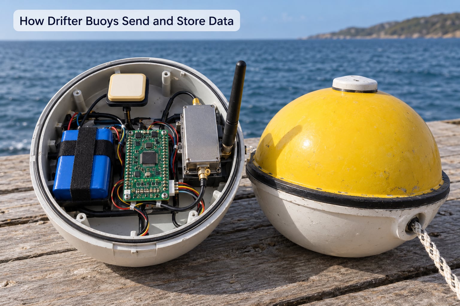
No drifter can stream everything it measures. A buoy measuring breaking waves at 50 samples a second produces far more data than any radio link could carry away, and the power to transmit it would end the mission in a week. So drifter telemetry is deliberately split in two.
The high-rate data stays onboard. An SD card or internal flash logs samples at whatever rate the science needs, and a GPS fix is written next to each one so it can be positioned later. The buoy is the tape recorder.
The low-rate summary goes to shore. Every few hours the controller wakes, gets a position fix, packages the interval’s data into a short message, and pushes it through the radio. Between transmissions the electronics sleep, which is where most of the battery life is saved.
Telemetry options compared
| Link | Bandwidth | Latency | Typical use |
|---|---|---|---|
| Satellite (Iridium SBD) | A few hundred bytes per message | Minutes to an hour | Open ocean, no coverage assumptions |
| Argos | Very low, location only on many models | Hours, location only | Large low-cost arrays where position is enough |
| Cellular | Moderate, firmware updates possible | Seconds | Coastal and fjord work within coverage |
| Acoustic | Very low | Seconds to minutes | Underwater moorings and AUV recovery |
The choice comes down to where the buoy will be. A coastal drifter can use cellular, get high bandwidth, pull fresh firmware remotely, and hand data over in near real time, but it dies the moment it drifts out of coverage. An open-ocean drifter has to assume there is no coverage, so it uses satellite and buffers everything onboard for store-and-forward.
Store-and-forward is the important behaviour. If a coastal drifter loses signal, it keeps logging. When signal returns, the backlog goes out. Readers looking at live maps sometimes see a straight line between two distant points that is actually weeks of buffered positions, not one huge jump.
The power budget is the design
Take a typical small drifter: a couple of amp-hours of lithium battery, a GPS receiver that draws tens of milliamps while it fixes, and a radio that peaks near a watt during transmission. Sleeping between events costs almost nothing. Transmitting costs more than everything else combined, which is why transmission interval is the main lever an engineer has on mission length.
Double the transmit frequency and you roughly halve the mission. That relationship is the single most useful thing to understand about drifter power, and it is also why a solar panel changes the design completely: with charging, a low-power buoyant hull can run indefinitely in summer instead of surviving one winter.
Brown-out is the classic failure. A radio drawing a high current from a nearly flat battery causes the voltage to collapse, the controller to reset mid-transmission, and the beacon to go deaf. Open builds solve it with a buffer, commonly a supercapacitor charged ahead of the transmit event, so the radio gets its current from the buffer rather than the battery.
Why the Drogue Matters: Stability Below the Surface
The drogue is a fabric or plastic drogue sock, roughly the size of a small barrel, held open by a weighted ring and attached to the end of the tether. Its whole job is drag. It is not a sensor and it does not report anything.
Its importance comes from what it disconnects. The float is exposed to wind stress and to the orbital motion of waves, both of which push the surface layer around. The drogue is 15 metres down in water that the wind barely touches and the wave orbits have largely decayed out of. So the drogue samples one current layer, the float samples air, and the two are physically separated by a tether.
That separation also gives a built-in measurement. The difference between the float’s velocity and the drogue’s velocity is an estimate of the wind applied to the surface layer. It is a rough instrument, but it is free, it needs no anemometer, and it works right up until the moment the drogue is lost.
The engineering tradeoffs
Drogue depth is the first lever, and it is limited at both ends. Too shallow and wave orbital motion dominates. Too deep and the tether drags, tangles, snags on floating debris and makes the assembly harder to keep balanced.
Drogue area is the second. A larger drogue has more drag relative to the float, so slip drops, but it also increases the chance of a snag and the risk that the assembly surfaces after a wave. Most designs settle on a ratio where the drogue’s drag dominates in any ordinary current but the whole system still behaves if the float takes a beating.
Material matters more than people expect. A drogue has to stay open and keep its shape for months, and it has to fail in a way the buoy can detect. Fabric wears at the attachment point first, which is ideal, because that is where the velocity change shows up in the data.
Attachment is the weak link by design. If the drogue were intended to survive a serious loss, the buoy would be lost with it. Engineers prefer the failure that costs only the drogue, and they design the detection to catch it.
What drogue loss does to the data
After the drogue goes, three things happen at once. Drift speed increases, because the float is now being pushed directly by wind instead of towing through deep water. Drift direction rotates downwind, often by 20 or 30 degrees in moderate conditions. The measured slip collapses, because the surface layer and the buoy are now moving together.
Good processing catches this automatically, by looking for the change in velocity relative to nearby drifters and for the wind slip signature. Data from before the event is still good. Data after it is measuring something different, usually the wind-driven surface layer, and most analyses exclude it or label it undrogued.
How Drifter Buoys Are Deployed and Recovered
Deployment sounds trivial, and the physical act is. You put a buoy over the side. Everything that matters happens in the two hours before and after that.
Before release, the drogue is deployed and checked, usually by confirming that the buoy leans away from the drogue’s pull rather than sitting balanced. A drogue that is not fully extended looks fine and then behaves badly. The ballast and freeboard are checked, the hull is inspected for damage, and the GPS is confirmed to have a fix with realistic position quality.
Tagging matters too. A drifter carries a unique identifier and a contact number for whoever finds it. Sea time is unpredictable, and a large fraction of drifters are recovered by fishermen rather than by the deploying institution.
Recovery is the reverse problem. You have a position, a window of weather, and often a ship far away. Because the buoy transmits its own position, finding it is the easy part. Catching it is not, so recovery is usually opportunistic: you go when a vessel is nearby, not when you choose.
On deck, the data comes off, the hull is washed and inspected, the drogue and tether are replaced, and the batteries are swapped. Drifters in national programmes are refurbished and redeployed for years. Small hobby builds usually get one mission out of the electronics and then get a fresh hull.
What Affects a Drifter Buoy’s Accuracy?
Drifter current data is good, but it is a measurement with conditions attached. The main error sources, roughly in order of how much they matter:
- Wind slip. Always present, and the reason drogue design is so conservative. It biases drift downwind and makes the buoy look faster than the water.
- Drogue loss. The largest discontinuity in a drifter record, and the one that must be detected and flagged.
- Current shear. The buoy measures one depth layer. A path that changes speed may be showing the drogue rising, falling or snagging, not the current changing.
- Waves. In heavy sea, the float is thrown around and the position fix becomes a mix of drift and orbital motion. Wave-period errors on drifter-derived velocities get large in a storm.
- Sensor calibration and fouling. Biofouling on a temperature inlet biases SST upward over months. A drifting sensor drifting toward warm water is indistinguishable from real warming unless you check.
- GPS error. A fix good to 10 metres, sampled at long intervals, gives a velocity that can be badly wrong when current speed is centimetres per second. Short intervals fix this and cost battery.
- Battery depletion. Near the end of a mission, the transmit event may fail, intervals stretch, and the track develops gaps that look like the buoy stopped.
- Shallow water and hazards. Grounding, fishing gear and floating debris all end missions early and leave recoverable wreckage behind.
How to read a drift track
Public drifter maps show why so many people ask about the loops. A clean path with roughly constant speed is a buoy tracking a steady current. A tight loop or squiggle is almost always a mesoscale eddy or a smaller rotating feature, and a drifter trapped in one will circle for days or weeks before it escapes.
Clusters of loops in a coastal region usually mean the flow is separating around something, a headland, an island or a shallow bank. A sudden straightening of the track is a change in the flow regime. A sudden jump in speed and a turn downwind is a drogue loss, not a current event.
None of that requires special software, but it does require knowing which flag in the data file the buoy’s status is stored in. Reading the track without checking that flag is how an undrogued record quietly contaminates a current map.
Drifter Buoys vs. Other Ocean-Tracking Instruments
Drifters get confused with moored buoys, Argo floats and gliders constantly, and the distinctions are worth having straight before you pick an instrument or read a dataset.
| Instrument | Position | Depth range | Power | Lifespan | Main measurement |
|---|---|---|---|---|---|
| Surface drifter | Free, moves with the current | Surface, drogue to about 15 m | Battery, sometimes solar | Months to years | Surface current, SST, wind, waves |
| Moored buoy | Fixed by mooring and anchor | Surface and fixed sensor depth | Large battery, sometimes solar and wave energy | Years to decades with servicing | Time series at one point |
| Argo profiling float | Free, rises and sinks on a cycle | Surface to about 2000 m, parking near 1000 m | Battery, energy-harvesting variants exist | About 4 to 5 years, then sunk | Temperature and salinity profiles |
| Underwater glider | Free, propellers, flies a sawtooth path | Surface to about 1000 m | Rechargeable, hours of endurance | Months, continuous piloting | Profiles, currents, planned transects |
| Autonomous sailing robot | Free, wind-driven on the surface | Surface with keel sensors | Solar, weeks to months per leg | Years | Shallow profiles, sampling under way |
What holds a sea buoy in place depends entirely on the type. A moored buoy is held by a mooring line and an anchor, with enough scope in the line to load the anchor rather than drag it. A drifter is held by nothing at all, which is precisely why it is a good current meter and a poor fixed station.
An Argo float is the mirror image of a drifter. The drifter samples the surface and follows the flow; the Argo float dives to about 2000 metres, samples a full profile of temperature and salinity, resurfaces to transmit, and sinks again. It is how the ocean’s heat content is measured. A drifter tells you what the surface water is doing right now, which is the input a weather model needs, and Argo tells you what the water column looks like below.
Gliders are for planned routes. They are slower, controllable, expensive per hour and impossible to recover reliably on a strict schedule. A drifter is cheap, uncrewed, expendable and follows the water whether you like the route or not.
Frequently Asked Questions
How do drifter buoys stay on the ocean surface?
A drifter stays on the surface because its hull is designed to be buoyant with a small ballast underneath that sets how much of it sits below the waterline. The hull floats well clear of the sea, keeps the electronics dry and the antennas in open sky, while a sensor inlet reaches down into the water for temperature. The underwater drogue is attached to a tether, not used as the flotation. If the hull took on water it would simply sink, which is why sealed housings and pressure-equalised electronics matter so much on a multi-month mission.
What is the drogue on a drifter buoy?
The drogue is a drag device, usually a fabric or plastic drogue sock held open by a weighted ring, that trails below the buoy on a tether at a standard depth of about 15 metres. Its only job is to create a large amount of drag in the water. Because that water is out of reach of direct wind stress and wave orbital motion, the drogue carries the buoy with the current rather than with the weather. Lose the drogue and the float becomes the only thing moving the system, so it speeds up and turns downwind.
How long can a drifter buoy operate at sea?
It depends almost entirely on power and how often it transmits. A small satellite-tracked drifter on a modest battery typically runs for months, while a solar-equipped drifter from a national programme can operate for years, sometimes past the point where anyone plans to recover it. The strongest lever is the transmission interval, because radio transmit draws more current than everything else combined. A hull that is simply buoyant with no solar charging, as on a fixed mooring, is a different category of device entirely and can be serviced for years.
What data can a drifter buoy collect?
At minimum, position from GPS and sea surface temperature from a thermistor, which together give you drift velocity. Common additions include wind speed and direction, air pressure, significant wave height and the full wave spectrum, subsurface temperature at a few depths, and salinity from a conductivity sensor. The buoy also reports its own status, drogue condition and battery voltage, which is what lets researchers detect drogue loss and filter the data. Everything is stored onboard at a high rate and transmitted as a low-rate summary.
Why does a drifter buoy not measure the current perfectly?
Because the float is still exposed to wind and waves even with a drogue attached, and the resulting wind slip adds a downwind push on top of the current. The drogue reduces that error enormously but never removes it, since the float has area in the wind no matter how heavy the drogue is. After drogue loss the slip increases sharply and the buoy is pushed mostly by direct wind drag. On top of that, currents vary with depth, so a buoy at 15 metres is not describing the surface water it is floating on.
Can a hobbyist build a satellite-tracking drifter buoy?
Yes. A sealed buoyant hull, a microcontroller, a GPS module, a temperature probe and a satellite modem are the core of it, and the failure modes are well documented: brown-out during transmit, which a supercapacitor buffer solves, and sensor fouling, which is the main reason measurements drift over months. Satellite messaging is the part that costs the most per device, and a cellular drifter is a much cheaper way to start if you stay near a coastline. Builders who publish their bill of materials and firmware get the most useful responses.
Conclusion
A drifter buoy works because of a deliberate separation: the float rides the wind and the waves, the drogue below follows the current, and the gap between those two is what makes the measurement trustworthy. Everything else, from the sensor inlet to the store-and-forward buffer, exists to capture data along that moving path and get it ashore without draining the battery.
The first practical step depends on what you are doing. If you are reading data, check the drogue flag on every track before you compute velocities from it. If you are deploying, confirm the drogue is fully extended and the buoy leans away from the pull. If you are designing one, work out your power budget and transmission interval before you pick a battery, because that decision sets the mission length and the sample rate together.